By Admin. Updated 12:23 p.m., Saturday, June 29, 2024, Atlantic Standard Time (GMT-4).
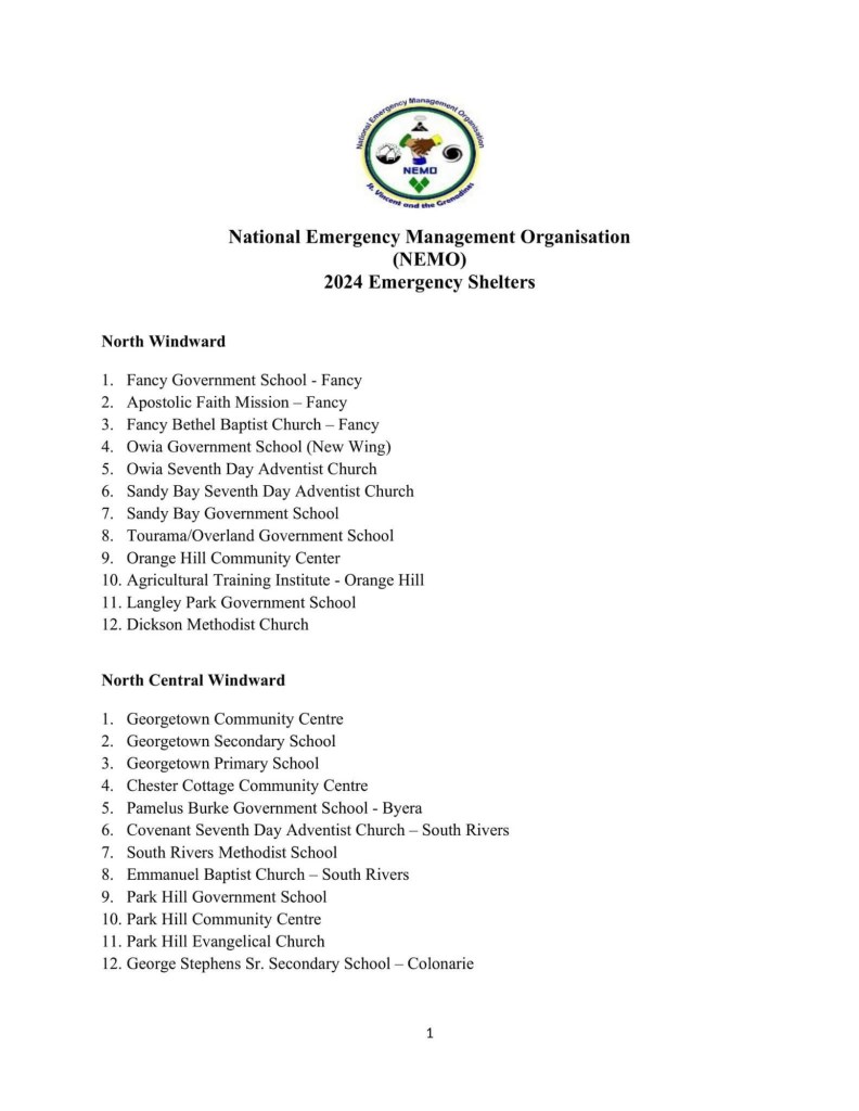
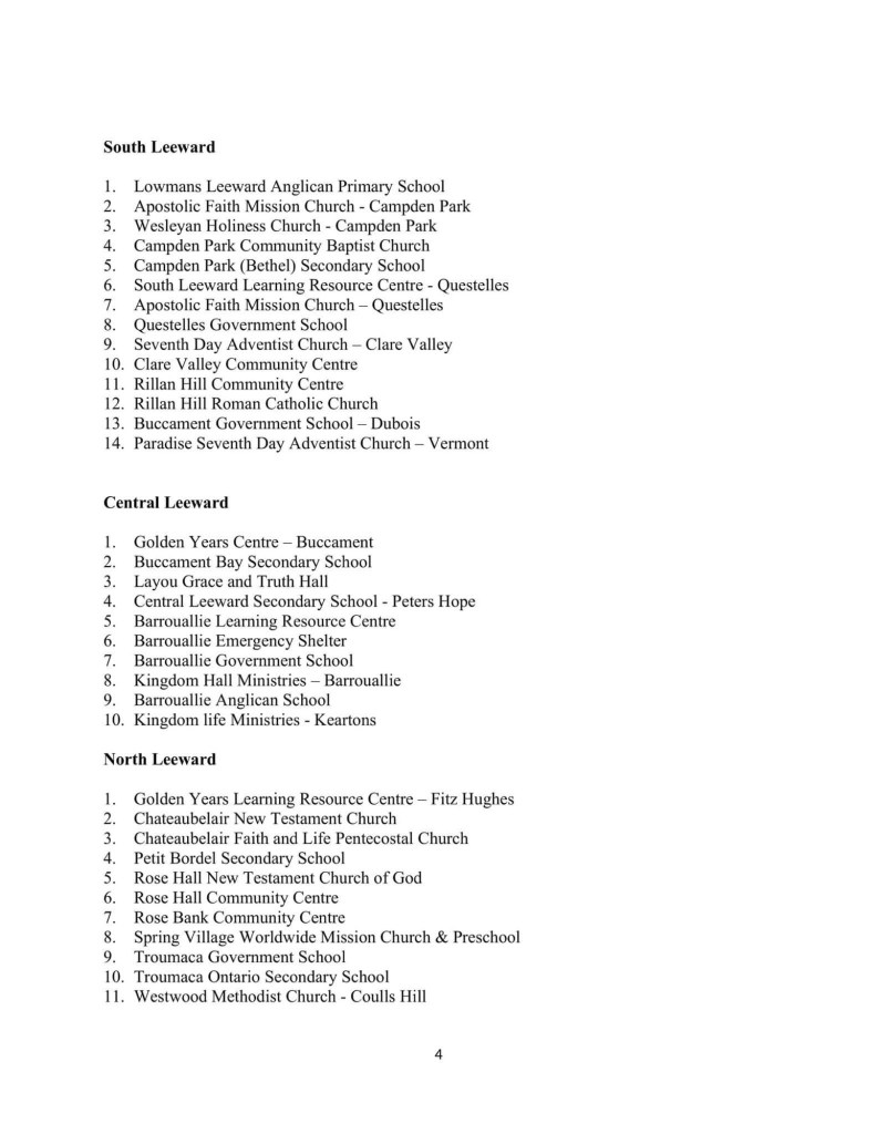
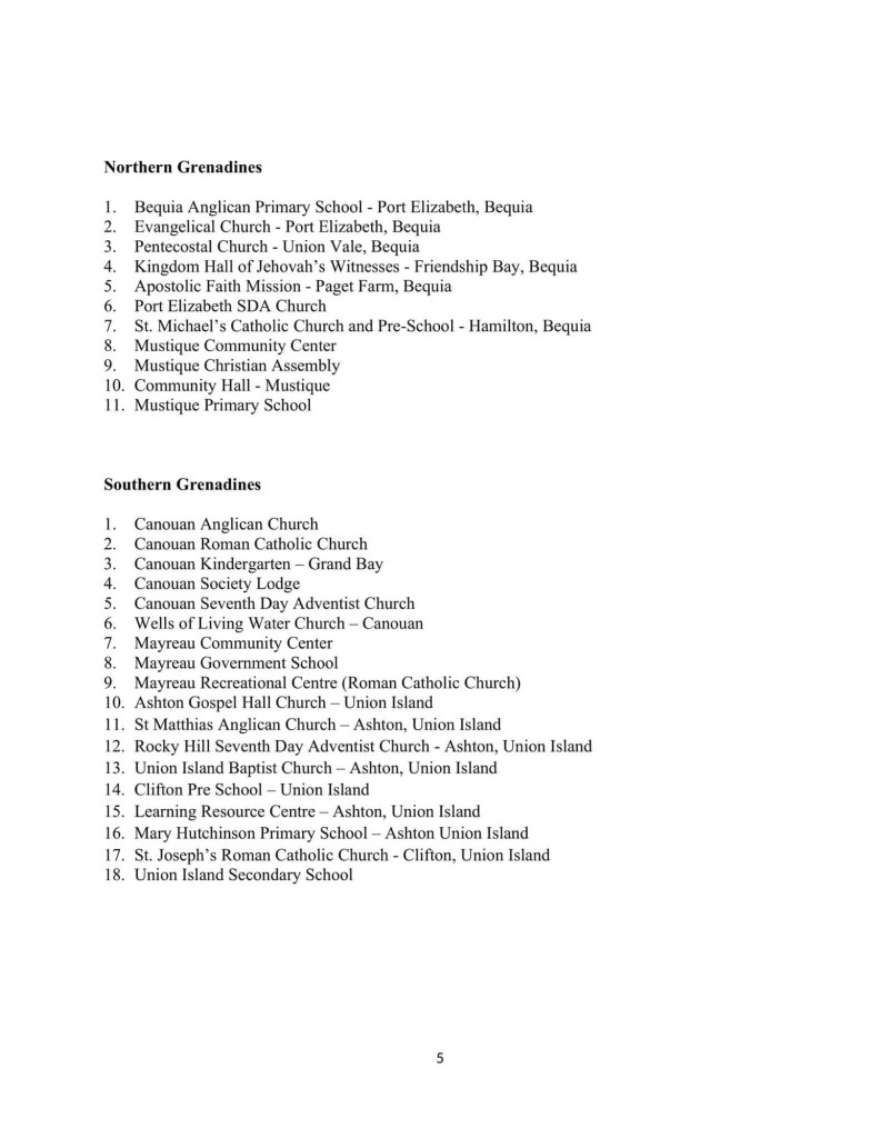
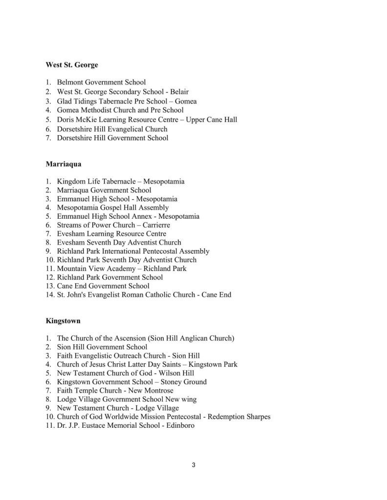
A LIST OF EMERGENCY SHELTERS IS FOUND AT THE END OF THIS ARTICLE.
Emergency shelters across St. Vincent and the Grenadines (SVG) will be activated at 6:00 p.m. on Sunday, June 30 as a tropical cyclone approaches the island.
The announcement was made today (June 29) by Prime Minister Dr. Ralph Gonsalves at a press conference.
The Prime Minister who is also the Minister of National Security said that based on forecast models, Tropical Storm Beryl is predicted to intensify into a hurricane which will pass over St. Vincent and the Grenadines late Sunday night into Monday morning.

The prime minister who is also the Chairman of the National Emergency Council of NEMO, has called on certain service providers like supermarkets and gas station operators to extend business hours later tonight.
He urged operators of marine vessels to secure their vessels and for fishermen to secure their boats, engines, and nets.
He urged all Permanent Secretaries to refuel all government vehicles and to secure their relevant officers and equipment. He also urged private sector businesses to secure their premises.
The prime minister also urged people who planned parties and other gatherings not to proceed as the police would not allow such gatherings.

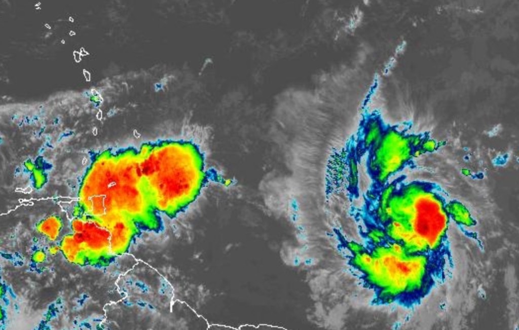
Dr. Gonsalves said the system at 11:00 a.m. today, the centre of Tropical Storm Beryl was located 10.0 degrees north, 47.8 degrees west, or 930 miles east of St. Vincent and the Grenadines with maximum sustained winds of nearing 65 miles per hour.
Hurricane-force winds are normally 74 miles per hour, he said.
A hurricane watch which was declared at 11:00 a.m. on Saturday 29th of June means that sustained winds of 74 miles per hour or greater are expected across St. Vincent and the Grenadines within the next 48 hours.
Beryl is expected to become a dangerous hurricane by the time it reaches near St. Vincent and the Grenadines which is predicted, given the current track of the storm, would hit us sometime mid-morning on Monday the 1st of July.
It is coming from the South of Barbados to the Southern Grenadines up into Bequia and on track to hit the Grenadines and St. Vincent then out to the Caribbean Sea.

Tropical storm conditions are likely to intensify across St. Vincent and the Grenadines by late Sunday night and category two hurricane conditions (and it may even be more than a category two hurricane) these conditions, category two or higher may well hit us in St. Vincent and the Grenadines by mid-morning Monday, the prime minister said.
Rainfall accumulations between 4-6 inches or even higher are likely across the country. He said normally, 2 inches of sustained rainfall inna relatively short period of time usually floods capital city Kingstown.
The marine conditions are expected to be very rough. Seas are going to be rough and hazardous with sea swells exceeding 13 feet, possibly higher, rising to 26 feet or more during Monday, he said.

Large and destructive waves, swells are likely to cause life-threatening surf and rip currents as well as storm surges across St. Vincent and the Grenadines, he added.
The prime minister said he, as the Chairman of the National Emergency Council of NEMO and as mandated by the National Emergency Management Organisation Act, called a meeting of all stakeholders and gave out instructions to all relevant parties.