
By Admin. Updated 9:57 p.m., Saturday, June 29, 2024, Atlantic Standard Time (GMT-4).
St. Vincent and the Grenadines (SVG) is now under a Hurricane Warning.
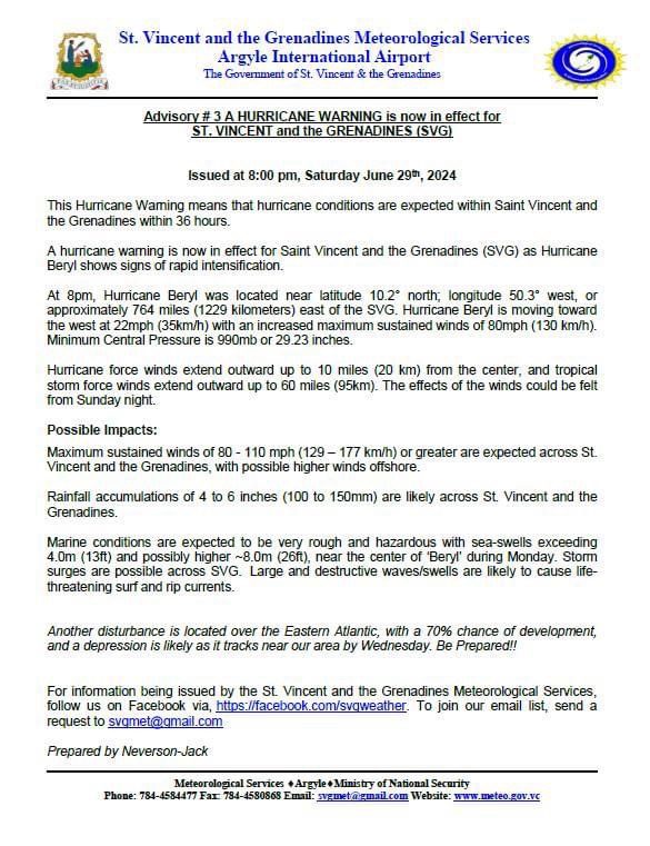
Advisory Number 3 issued tonight by the St. Vincent and the Grenadines Meteorological Services (SVG Met Office) stated that this Hurricane Warning means that hurricane conditions are expected within Saint Vincent and the Grenadines within 36 hours.
The warning comes as Hurricane Beryl shows signs of rapid intensification.

At 8pm, Hurricane Beryl was located near latitude 10.2° north; longitude 50.3° west, or approximately 764 miles (1229 kilometers) east of the SVG. Hurricane Beryl is moving toward the west at 22mph (35km/h) with an increased maximum sustained winds of 80mph (130 km/h). Minimum Central Pressure is 990mb or 29.23 inches, the Met Office said in the Advisory.
Hurricane force winds extend outward up to 10 miles (20 km) from the center, and tropical storm force winds extend outward up to 60 miles (95km). The effects of the winds could be felt from Sunday night, the Met Office said.
The Met Office also presented some possible impacts, as follows:
Maximum sustained winds of 80 – 110 mph (129 – 177 km/h) or greater are expected across St.
Vincent and the Grenadines, with possible higher winds offshore.

Rainfall accumulations of 4 to 6 inches (100 to 150mm) are likely across St. Vincent and the Grenadines.
Marine conditions are expected to be very rough and hazardous with sea-swells exceeding 4.0m (13ft) and possibly higher ~8.0m (26ft), near the center of ‘Beryl’ during Monday. Storm surges are possible across SVG. Large and destructive waves/swells are likely to cause life-threatening surf and rip currents.
Another disturbance is located over the Eastern Atlantic, with a 70% chance of development, and a depression is likely as it tracks near our area by Wednesday. Be Prepared!!